|
dRonin
adbada4
dRonin GCS
|
|
dRonin
adbada4
dRonin GCS
|
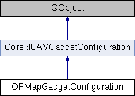
#include <opmapgadgetconfiguration.h>

Public Slots | |
| void | setMapProvider (QString provider) |
| void | setZoom (int zoom) |
| void | setLatitude (double latitude) |
| void | setOpacity (qreal value) |
| void | setLongitude (double longitude) |
| void | setShowTileGridLines (bool showTileGridLines) |
| void | setAccessMode (QString accessMode) |
| void | setUseMemoryCache (bool useMemoryCache) |
| void | setCacheLocation (QString cacheLocation) |
| void | setUavSymbol (QString symbol) |
| void | setMaxUpdateRate (int update_rate) |
| void | setUserImageLocation (QString userImageLocation) |
| void | setUserImageHorizontalScale (float userImageHorizontalScale) |
| void | setUserImageVerticalScale (float userImageVerticalScale) |
| void | setGeoLanguage (QString language) |
Public Member Functions | |
| OPMapGadgetConfiguration (QString classId, QSettings *qSettings=nullptr, QObject *parent=nullptr) | |
| void | saveConfig (QSettings *settings) const |
| IUAVGadgetConfiguration * | clone () |
| QString | geoLanguage () const |
| QString | mapProvider () const |
| int | zoom () const |
| double | latitude () const |
| double | longitude () const |
| bool | showTileGridLines () const |
| QString | accessMode () const |
| bool | useMemoryCache () const |
| QString | cacheLocation () const |
| QString | uavSymbol () const |
| int | maxUpdateRate () const |
| qreal | opacity () const |
| void | saveConfig () const |
| QString | getUserImageLocation () |
| float | getUserImageHorizontalScale () |
| float | getUserImageVerticalScale () |
 Public Member Functions inherited from Core::IUAVGadgetConfiguration Public Member Functions inherited from Core::IUAVGadgetConfiguration | |
| IUAVGadgetConfiguration (QString classId, QObject *parent=nullptr) | |
| QString | classId () |
| QString | name () |
| void | setName (QString name) |
| QString | provisionalName () |
| void | setProvisionalName (QString name) |
| bool | locked () const |
| void | setLocked (bool locked) |
| virtual void | saveConfig (QSettings *settings, UAVConfigInfo *) const |
Properties | |
| QString | mapProvider |
| QString | geoLanguage |
| int | zoommo |
| double | latitude |
| double | longitude |
| bool | showTileGridLines |
| QString | accessMode |
| bool | useMemoryCache |
| QString | cacheLocation |
| QString | uavSymbol |
| int | maxUpdateRate |
| qreal | overlayOpacity |
Definition at line 36 of file opmapgadgetconfiguration.h.